Tracing Water Levels at Walden Pond
Primack: historical precedent for one of Walden’s endearing quirks
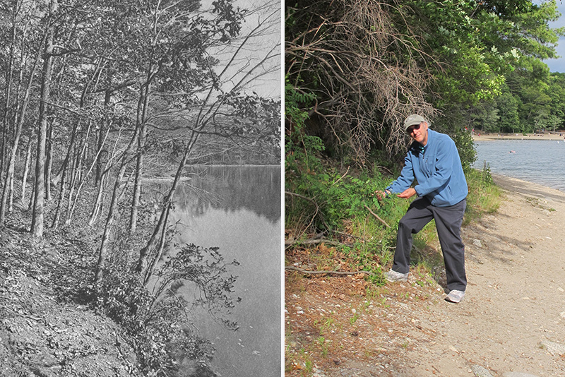
Left: High water levels at Walden Pond, circa 1906. Photo courtesy of the Walden Woods Project. Right: BU biology professor Richard Primack, in June 2016, standing on Walden Pond sandbar created by cyclical low water level. Fluctuating water levels dictate the ecology of the pond, says Primack. Photo courtesy of Richard Primack
In spring 2016 Walden Pond is low, exceptionally so. Visitors are enjoying the broad expanse of sandy margins around much of the pond; they can walk and play without being confined to the trails and main swimming beach. This low water represents the extreme end of a drawdown that has been happening (irregularly) since the pond’s recent high in the spring of 2010, when water entered the forest around the pond and even flooded the paths. The contrast between these high- and low-water years is striking.
These changes in water level, however, are not new—they are one of Walden’s endearing quirks. As Henry David Thoreau noted 160 years ago in Walden: “The Pond rises and falls, but whether regularly or not, and within what period, nobody knows, though, as usual, many pretend to know. It is commonly higher in the winter and lower in the summer, though not corresponding to the general wet and dryness.”
Walden Pond’s ups and downs dictate much of the ecology of the pond. High water strangles encroaching trees and shrubs, helping to keep the pond margins open. Thoreau noted in his journal, “This great rise of the pond after an interval of many years, and the water standing at a great height for a year or more, kills the shrubs and trees about its edge—pitch pines, birches, alders, aspens, etc.—and falling again, leaves an unobstructed shore.”
The past few years of low water have allowed alder and birch saplings and wildflowers, such as lance-leaved violets and yellow wood sorrel, to establish on the sandy beaches below the forest margin. Many non-native plants have also established, including coltsfoot, vetch, and dandelion. When the water rises again in coming years, this invading edge of plants will be drowned.
The water has fallen so low this year that part of a submerged sand bar—one that Thoreau described in his survey of Walden Pond—is now exposed. In Thoreau’s 1846 survey, he noted that the sandbar across the mouth of what is now known as Thoreau’s Cove on the northwest corner of the pond (the cove closest to the site of Thoreau’s cabin) was 7 feet below the water’s surface; water was 28 feet deep on the pond side of the bar and 20 feet deep on the cove side. Right now the sand bar extends above water from the eastern edge of the cove pointing toward the railroad.
艾尔
The irregular cycle of high and low water creates a cycle of winners and losers, good years and bad years, depending on your perspective, whether you are a colonizing plant, a breeding salamander, a hungry fish, or a visitor enjoying the beach. The extreme low water and wide beaches that we are seeing this year—an extreme that Thoreau noted, too—is a part of what makes Walden Pond so endlessly fascinating. Something to consider next time you take a stroll around the pond.
Richard B. Primack is a professor of biology at Boston University and the author of the book Walden Warming: Climate Change Comes to Thoreau’s Woods. For the past 14 years, Primack, along with his students and colleagues, has been investigating the effects of a warming climate on the plants and animals of Concord, building on the observations of Henry David Thoreau from the 1850s.
A version of this article was originally published in Wicked Local.
Comments & Discussion
Boston University moderates comments to facilitate an informed, substantive, civil conversation. Abusive, profane, self-promotional, misleading, incoherent or off-topic comments will be rejected. Moderators are staffed during regular business hours (EST) and can only accept comments written in English. Statistics or facts must include a citation or a link to the citation.